The Trans-Canadian Highway West
Whew! Okay, now that all that philosophical
bullshit is done, here's the narrative from Saturday morning until I got to
Vancouver Island on Sunday.

The car cleaned,
my clothes cleaned, my Tevas no longer odorous, my hair washed, and in a better
 frame of mind I headed for Sulphur Mountain, home of the Banff Gondola. Said Gondola takes you from 5,200 feet to
7,486 feet, from which point you can walk along the ridge to a slightly higher
overlook. The higher overlook is the
site of a metereological station that Norman Sanson hiked to every week for
something like fourty years. The hike
over to the Sanson station was easy, but there was an extension that diverged
from the developed path and wound around the summit below the station that I
walked down for a bit, and then returned back up. It was a great little walk.
frame of mind I headed for Sulphur Mountain, home of the Banff Gondola. Said Gondola takes you from 5,200 feet to
7,486 feet, from which point you can walk along the ridge to a slightly higher
overlook. The higher overlook is the
site of a metereological station that Norman Sanson hiked to every week for
something like fourty years. The hike
over to the Sanson station was easy, but there was an extension that diverged
from the developed path and wound around the summit below the station that I
walked down for a bit, and then returned back up. It was a great little walk.

After that
adventure, it occurred to me that while I couldn't afford the Banff Springs
Hotel, the golf course might have a twilight rate worth pursuing. The course is on my punch list of golf
courses that I hope to work on someday, and since I was here...well, what the
hell! They did have a twilight rate,
though it was still high enough to give me pause, but I made a 3:20 tee time
and headed out to find the camping site that I had reserved for the night.
When I arrived at
the campground there was a loonnnnggg line to get in. Not being a fan of long lines, I ran up past
the line and turned around to come back to the other side of the office. I asked that clerk if there might be a better
time of day to return as I had a reservation and so would prefer not to spend
so long waiting. She said, "I can
help you," and boom, I was checked in.
Not sure if this will be true for all my camping at Canadian parks, but
while the site was more expensive than US parks, it was very service
oriented. Definitely a good place to
camp.


It was lovely to
play a round of golf. I had some
feelings of guilt for the splurge, but that's why they call splurges guilty
pleasures, yes? At first I was playing
as a single, but after about six holes I caught up with three other guys who
were there on business (nice place for a business meeting!) The course was in excellent condition and
provided a challenging but manageable layout.
What makes it a world class, bucket list course is not really the course
itself, as I have played courses that made better use of the terrain or offered
more extraordinary design, but the environment is not to be matched. Banff is a strange place as a natural
park. It is very developed and
commercial, yet the way that the mountains explode out of the ground around you
and surge skyward is nothing short of miraculous. Everywhere you go, if you
 look up there is an
enormous mountain looming over you. As
usual, I hit some great shots and had a string of stupid holes. My biggest problem was that since I was
playing at 5,000 feet and hitting the course clubs, distances were
difficult. After hitting over several
greens I finally realized that I could hit a 56 degree wedge 110 yards, which
is a really long way. Interesting that
the course measured distances in yards, but everywhere else in Canada things
are metric.
look up there is an
enormous mountain looming over you. As
usual, I hit some great shots and had a string of stupid holes. My biggest problem was that since I was
playing at 5,000 feet and hitting the course clubs, distances were
difficult. After hitting over several
greens I finally realized that I could hit a 56 degree wedge 110 yards, which
is a really long way. Interesting that
the course measured distances in yards, but everywhere else in Canada things
are metric.

After the golf I
headed to the campground and enjoyed a quiet evening waiting for dark to settle
in and to get to sleep. Amazingly, I
slept until almost eight Saturday morning, which is the first time during this
journey that I slept in. Its been a hard
couple of days and I think I was tired.
Of course, the fact that I got up and peed at 3:30 in the morning, so I
wasn't pushed out of bed by nature's call in the morning may have had an
influence on that.
It was good to
take my time in Banff, and to have time to write and reflect. At the same time, it was a really expensive
place, even to camp. After leaving the
campground I headed into town to the Starbuck’s, wrote the blog that I posted
Saturday morning, and made my way to the Cave and Hot Springs National Park
located by the river in Banff. It is the
site of the first national park in Canada, so it is as much a park about parks
as anything else. It was interesting to
note in the historical exhibits that Canada has struggled with the tendency to
displace and ignore indigenous peoples in the same way that the United States
has; though they don’t appear to have engaged in such widespread and systematic
genocide as we did. The hot springs were
quaint, and it was here that I began to think about the fact that the most
interesting element of the trip is not so much the beautiful scenery I am
encountering, as the folks who are there to see it or the folks for whom it is
their livelihood.
I left the park
and headed down the TransCanada toward Lake Louise, exiting almost immediately
to take the Bow River Parkway, which is the scenic route to Lake Louise. Once again, the scenery is extraordinary. Although I was not highly motivated to stop
at the various turnouts along the way, one spot boasted a set of falls and the
possibility of a hike. I pulled into the
lot, fully expecting to exit stage
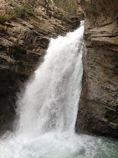 left as soon as the crowds deterred me, when
a spot suddenly opened up right in front of me.
Time to park and sightsee. I got
out and nosed around the parking lot.
There were people with ice cream, which suggested the presence of honey
glazed tourist baited items, but all I could see were a set of highly
utilitarian washrooms and an information kiosk.
I could see from the kiosk that there was a nice little hike up to the
lower falls of Thompson Creek, so I trooped back to my car, changed into garb
more appropriate for hiking, and set off on my way up the trail…which
immediately crossed a small bridge to reveal another parking lot and the
anticipated tourist trap. A quaint shop,
an ice cream stand, a restaurant claiming to have the best burger in somewhere,
I don’t recall the scope of their claim, and oodles of families and folks left,
right and center. I headed up the paved
walkway and was soon happily strolling along yet another roaring creek in a
dramatic canyon.
left as soon as the crowds deterred me, when
a spot suddenly opened up right in front of me.
Time to park and sightsee. I got
out and nosed around the parking lot.
There were people with ice cream, which suggested the presence of honey
glazed tourist baited items, but all I could see were a set of highly
utilitarian washrooms and an information kiosk.
I could see from the kiosk that there was a nice little hike up to the
lower falls of Thompson Creek, so I trooped back to my car, changed into garb
more appropriate for hiking, and set off on my way up the trail…which
immediately crossed a small bridge to reveal another parking lot and the
anticipated tourist trap. A quaint shop,
an ice cream stand, a restaurant claiming to have the best burger in somewhere,
I don’t recall the scope of their claim, and oodles of families and folks left,
right and center. I headed up the paved
walkway and was soon happily strolling along yet another roaring creek in a
dramatic canyon.

After walking a
ways up the canyon, I started to consider strategies for taking pictures of
people, rather than scenery. At this
point all I had was my phone, and somehow it seemed socially inappropriate to
start aiming my phone at random people and snapping their picture. Initially, I managed to capture the backs of
some very interesting tourists as I contemplated this new challenge. The first truly interesting shot I got was of
an older Asian woman who was sitting on a bunch. I surreptitiously set up as if to take a
photo of the canyon beyond her, and managed to get a fuzzy picture in which she
was too small. I continued up the
canyon, eventually reaching the lower falls previously advertised, snapping
these furtive shots along the way. There
was a small cave which led closer to the falls and for which folks were waiting
in line. As folks went in, folks came
out, since it was a dead end at the falls.
The trio in front of me included a young lady and two young men. One young man was translating from French to
English for the young lady, who appeared to speak mostly French while the other
young man spoke only English. They were
clearly together, since they all had cans of Bud Light. When we reached the front, I took their
picture for them, but throughout I was playing the “what’s their story”
game.

A note about
bugs and mosquitoes in Banff…they are aggressive. They appeared the first time at the golf
course, where they ambushed me as I stepped from the cart in the shade of a
tree by the 11th green. They
were not always on the attack, but when they were there was no ignoring
them. At the campsite, they were just
annoying enough for me to change into long pants and shirt earlier than
preferred, and at various times in my walk at the creek they made their
presence known. It was much more like
Minnesota than the insects of the Rockies south of the border. A little more moisture results in more
picturesque scenery, but also in more ferocious mosquitoes.
I continued down
the Bow River Parkway, which, in turn, continued to offer amazing views. The entire Banff area is striking because the
glacial activity which formed the area created these enormous U shaped valleys that
are surrounded by dramatic peaks. It
stands in contrast to the Rockies in the US in that our mountains, while having
been subject to glaciation, seem to have a more complex set of erosive powers
including glaciers, water and weather.
Glacier National in Montana has some of this influence, but it was most
striking at Banff. At Lake Louise I
returned to the TransCanada and headed off toward Vancouver. Before too long I came to the turn off for
the Icefields Parkway, which promised a spectacular drive through ice fields to
the north of the Banff and Lake Louise area.
I was tempted, but ready to move on to a new adventure, so I let it
go.
The drive from
Banff to Vancouver, which I took entirely on the Trans-Canada highway, is
beautiful from end to end. It begins as
I describe above, with an ongoing series of valleys surrounded by high
peaks. Each valley has at its end the
view of a new set of snow-covered peaks, which as they are approached and the
valley turns in a new direction are replaced by a new set of snow-covered
peaks. As I moved through the area that
they marked as their Glacier National Park the peaks often contained snow
fields that must have been glaciers, given their size and that it is already
late July. In one particular spot there
is a large glacial field above the higway to the left that is the largest
glacier I have seen since I was in Alaska some years ago.
One interesting
feature of the highway that I still am not sure of the explanation for was
located just prior to the large glacier.
There is a series of tunnels through which the highway runs, but the
tunnels are open on the river side (away from the peaks on the right of the
road). The ground above these tunnels is
not generally particularly rocky or cliff-like, such that it seems like the
road could have simply been cut through this area without the need for a
tunnel. I considered the possibility
that the tunnel was to protect from rock falls, but most of the terrain was
tree-covered. My working hypothesis at
this point is that the tunnels are located in areas where snow slides are most
common, but I don’t know. Have to look
it up when I’ve got internet…
After leaving
the glacial area, the valleys begin to widen and eventually the land changes to
support ranching and farming in the green spaces between the ridges. I crossed the Columbia River in this area,
though I did not realize it until I was looking at the map some time
later. After this point you are
following first the Thompson and then the Fraser rivers, and at the times when
the road climbed out of the valley and into the spaces not supported by a major
flowage the terrain became almost Wyoming like in that it was dry and
barren. Just to make sure that there was
yet another scenic element available to the traveler in British Columbia, there
is a series of large lakes which appear to be naturally formed by deep chasms
in the river valley, though there may have been dams helping to ensure the
lakes were formed. In any event, these
lakes created entire recreational areas with marinas and extensive tourism
economies. The areas were very beautiful
and ran from the somewhat rustic to lives of the rich and famous. At the head of one of these lakes a large
collection of logs were captured within booms and seemed to be waiting to
either head downstream, or to get loaded onto trains having already come
downstream.
I spent the
night on Sunday in an Econolodge in a place called Kamloops. It was a serviceable place and I met a family
at the pool who were moving to Prince George, which is apparently north of
Vancouver. Sunday morning I headed off
again toward Vancouver without pausing for my morning writing session as it
seemed that Kamloops would not be likely to support a Starbucks…but I was wrong
as there was one of the highway on the south side of town. Wanting to move along and expecting to write
later in the day, I passed it by.
Besides, I already had my coffee for the morning.
After crossing
through a space with fewer, smaller mountains the path began to narrow again,
and before long the Fraser river valley was once again lined with snow-capped
mountains and had a rushing river running dramatically through its narrow
valley. A feature of the road that you
won’t find in the US is that at regular intervals are signs indicating the
station settings for the local broadcasting station for the CBC, the Canadian
version of NPR. The fact that these
signs were provided by the government suggests a stronger support for public
radio than we have in the states. In
addition, there are probably more CBC stations here, as there were many times
when the ONLY station available was the CBC (and sometimes even that was lost
to me). There were a number of little
things like this that unpacked the presence of a stronger central government…or
perhaps it might be more accurate to say that there appears to be a stronger
social contract here. There appear to be
more laws governing little things, like you have to prepay for gas in BC, it’s
a provincial law, and non of the gas pumps have handle locks, so you have to
hold onto the pump handle the whole time.
It’s a small thing, but I can see both of these centralized solutions to
widespread but inconsequential problems (no pay drive aways and gas spills)
having come from a legislature more comfortable with regulating individual
behaviors. On CBC this morning, which I
listened to when I could, there was an hour long discussion about whether
retailers should have the right to charge a fee for credit card users who used higher
fee cards. It was a strange conversation
to listen to, since the answer in the US would almost always be, of
course. To us, a retailer should be able
to charge whatever the market would be willing to pay for. If a retailer charged a fee for cc use, then
another retailer could choose not to, which in the end would likely discontinue
the practice. The real issue seemed to
be the fact that different cards charge merchants different rates. I could see us discussing possible banking
regulations to ensure that fees match actual costs rather (to prevent gouging)
but that would be the end of that.
Amusingly, even with my socialist leanings, I was inclined to think
these people who called in were crazy to suggest that merchants should not have
the right to charge customers a fee based on the cards they used. “Why not,” I thought? I guess I’m at least a little bit of a
capitalist.
Eventually, the
terrain widened out again, and about an hour outside of Vancouver I was
suddenly back in the kind of commercialized version of civilization that I
hadn’t seen since I left Denver exactly one week ago. Another comment about differences in Canada
has to do with the highways. The
Trans-Canada Highway, which is the major thoroughfare across Canada, has an
extraordinarily wide range of conditions for something of its ilk. The name would, in the US, suggest a wide
boulevard running straight and true through the heart of the nation. Instead, the Trans-Canada ranges from a very
interstate-like divided four lane highway, to areas where the two lanes left to
motorists are winding through tight turns.
At one point the speed limit shifted from 100 km/h to 40 km/h within a
very short span. It was pleasant, in
that there was a great deal of variety and engagement in the journey. Also, while negotiating through Vancouver, at
one point I was supposed to turn right, “when you hit the highway”. Of course, I was looking for an on-ramp to a
controlled freeway, when suddenly I realized that the light I was sitting at
was, in fact, the intersection with the highway. I took what was no doubt an illegal turn and
headed on my way.
One of my
challenges at this juncture is that my phone is turned off to avoid
international roaming charges. I could
probably fix this and get some kind of affordable service, but until now I was
in parks, so who really cared?
Navigating a major metropolitan area, however, is greatly eased by ones
smartphone. On a whim, as I entered
Vancouver, there was a sign indicating that 104th street was the
last exit before the toll bridge. I had
no idea where the toll bridge went, so I decided at the very last second to
veer wildly off the highway and soon found myself rolling along on 104th
Street or Avenue…not sure which it was.
A series of local and chain establishments wandered by, a hospital, a
whole raft of car dealerships, but no indication of where I might be. I was looking for a likely place to stop and
consult my somewhat less than detailed atlas, when a Jiffy Lube appeared. Eureka!
An oil change would be just the ticket.
I pulled across three lanes of traffic and found my way to the
entrance. The service guys were funny
and helpful and had me in and out in short order…complete with a code for a car
wash next door and vague directions to the ferry terminal (the ones that
indicated a right turn at “the highway”.)
The attendant at the car wash, when encountering the comment, “Beautiful
day, isn’t it,” responded by observing he could do without the heat. It’s 72 degrees out. Everything is, in fact, relative.
So, once again,
the car washed, me washed, and this time with an oil change, I headed for the
ferry terminal. I should mention that up
until that morning the ferry terminal had not been on the itinerary. The whole reason I am in Vancouver was to see
a performance of Bard on the Beach here, but it being Sunday, and both
performances being sold out, and the next performances not scheduled until
Wednesday, I moved on from Bard on the Beach to a suggestion that I check out
Vancouver Island…which requires a ferry ride.


Comments